Where I am not…
 Nope, I am not kayaking on the edge of the shipping channel in the upper St. Mary’s River, which connects Lake Huron and Lake Michigan to Lake Superior. When this photoooo was taken — I think I received it in the early afternoon — I was sitting pretty contentedly in my loverly, dog-poopy cube here on The Planet Ann Arbor. The one that I drove to this morning in my loverly, red winged blackbird-poopy vee-hickle.
It isn’t often that the weather in the upper St. Mary’s River is conducive to kayaking all the way out to the shipping channel. Especially by afternoon. Many a morning, we will wake up to absolutely dead calm conditions. Sometime between, oh about 10 AM and noon, a breeze will ripple the water a bit. By afternoon, there’ll be fairly significant wave action. Arguably enough to keep our little 12-foot (?) Walden Vistas from venturing too far out. Well, that is when the wind isn’t engaged in blowing an good old three day gale. (The GG had an aunt named Gale and she used to describe the spelling as, “you know, like the wind”. Yes, I know. Grew up on L. Superior, yada yada.) But on most days, if you want to take any kind of a serious kayak trip on the upper St. Mary’s River, it’s best to get out there early. There is a LOT of water out there and it does not look ANYTHING like most rivers.
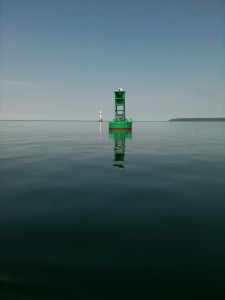
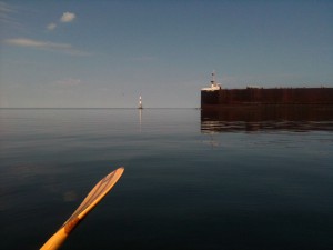
Looks like this was a prime day for kayaking the upper St. Marys River!
 That’s “Marker” 25 there in the foreground (uh, “Buoy” 25? (Buoy 22 is in my back yard but that’s a whole ‘nother story…)) and, if you squint (or click on either pic to enlarge it (I refuse to use the “word” embiggen (but I reserve my right to change my mind tomorrow))), you will see the Pickle Finger in the background. Back in the Jurassic Age, when Grandroobly was still galumphing around and I invented children, we had a
 spanner scanner in the moomincabin. I don’t mean the kind of spanner scanner you use for all yer old fambly photoooos. I mean the kind where you can listen to the police discuss “subjects” that are caught peeing in public, like behind the Alphaaaa Barrrooom or wherever. And the captains of lake freighters calling in their location to the Coast Guard Master Control. Or whatever it was called. What with Homeland Security and New Technology, they do not call in at Light 26 (aka the Pickle Finger) any more and so, a few years ago, we discontinued the spanner scanner (aka turned it off “forever” (it may yet live again but that’s a topic for another day)). Anyway… (man am I ever digressing tonight…) Anyway If you have gotten this far, the Pickle Finger wasn’t always there. It wasn’t there when I was a beach urchin. They were building it one summer when my own beach urchins were toddler/pre-school age. Radical Betty kept referring [in a not too friendly manner…] to that new construction out there as “The Fickle Finger of Fate”. I never quite got it (speak s-l-o-w-l-y. I’m blonde) but one of the young family members who shares her name with Radical Betty aka Lizard Breath interpreted that as The Pickle Finger. And so that is what it is.
That was more of less the beginning of the era during which we spent years and years and years listening to the spanner scanner as lakeboat captains called in. From 15 miles (I think?) above Light 26 The Pickle Finger and then at the Pickle Finger and again at Point Louise and again at many points below the locks. In more recent years, we would be sitting on the moominbeach. We would spot “something” coming down. Way too far out for us to have any idea what it was, especially if there was some kind of mirage going on. Grandroobly would appear at the top of the bank and announce that the James Barker (or whatver) was downbound. Honestly, we were all so addle-brained (or at least I was) that it took a good while to realize that he knew which blasted boat it was because he had been listening to the dern spanner scanner.
July 7th, 2011 at 9:30 pm
That water looks deceptively calm and peaceful. I would like to get a canoe-husband and I talked about it before this damn cancer stuff. Now we’ll see.