Geek travel decompression
 I bailed out of work a little bit early today because we drove (again) to Houghton Lake. It wasn’t really all that hot around the Planet Ann Arbor today but it was humid and I felt really slodgy all day and then I had a cup of coffee in the afternoon so, when I finally got home, I was kind of slodgy and waarrrred up all at the same time. Not cool. I was being all uppity about wanting to do the driving and then I remembered that we had That Device (aka the iPad) and I talked myself down off of that ledge. Why? Because, ladies and gentlemen, with That Device, I can actually sit in the passenger seat of the Dogha and watch us drive up north. And, believe it or not, doing just that was *eventually* what got me to decompress and enjoy the bumpity clunkety ride up the I75 SUV Speedway. Except for the part where the GG was going 80 past the West Branch Speedtraps. No, he didn’t get caught.
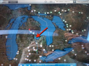
Anyway, that’s a really crappy photo that I took with my iPhone. It is a satellite view of the Great Lake State (er, part of it anyway) and the big red arrow that I photoshopped in there is pointing to a blue dot and that blue dot is *us* bumpity-clunking along. I have the iPad way zoomed out for the photo because I think it is cool looking at the Great Lake State surrounded by, you know, the Great Lakes. If I zoom it in close enough, I can actually watch the blue dot move along.
When I was a kid, we traveled a lot. Up and down and around the Great Lake State, sometimes venturing into the neighboring states or the province Ontario or beyond. I learned early on how to read maps and highway signs and I would often sit in the back seat and read the map. How far is it from Sault Ste. Siberia to the Motor City? How many miles is it between this little town and that little town? What is the population of this town or that city? Is it larger or smaller than the population of Sault Ste. Siberia? Or the Motor City? Except that, in my little world, the Motor City was the biggest and coolest city on earth. But that would be a whole ‘nother topic. Today I was just doing what I used to do when I was a kid except now I have some really cool technology to do it with.
All in all, it was a very smooth trip and we made it here in near record time and The Beautiful Gay is here making dinner and I am pretty well decompressed (knock on wood). Times have changed and travel is changing. It is not that many years since I first had a viable wifi laptop and sometimes when we were traveling, I would have to MacStumble around looking for an open wifi so I could post a blahg entry. And then we got our iPhones and click here if you want to read about our *loverly* trip to Chicago along the Internet Highway a few years ago. The post I wrote because I could not write how I felt about dropping my “baby” off at O’Hare to catch a flight to Dakar.
Cheers! -KW
June 11th, 2010 at 7:50 pm
I remember you writing on my blog on my post about leaving Ashley at the airport for Dakar. It is amazing to see the blue dot at all; it would be freaky to see it actually moving. My husband would claim that we’re all being tracked by The Government, so I won’t show him this. 😉
June 11th, 2010 at 8:02 pm
They have that kind of blue dot on the map progress screen on international flights too. It is kind of reassuring to watch as you arc towards your destination.
I joked with some friends from a very small town in WA, east of the mountains, and towards the Canadian border, because their town was one of the ones randomly listed on our map as we flew into Seattle from Amsterdam. Who knew?
I’ll lift a G&T to you, here’s to the weekend!
June 14th, 2010 at 8:08 am
Found a new app called Imapmyride. you can use it for recording a bike ride or a walk. I played around with it when I walked to the Metrolink, so I could see my own little blue dot progressing.