Forest faaarrrr [insert 4-letter-word that begins with “p” and ends with “n”]
 Approximately one year ago, the GG and Lizard Breath were up here at the moomincabin having too much fun [while KW slaved away in the salt mines] and when they got up one morning, there was SMOKE outside! Where was the fire? They looked around outside and somebody called the DNR to try to figure out what was going on. The moomincabin is located in a forest and when it gets dry, any little spark could set off a conflagration in no time. Forest fires are *good* in the grand scheme of things but not so much when they occur in areas where people own property on which they have built structures. Like us. That’s why we are ULTRA-careful with beach faaaarrrs around here.
It turned out that there was indeed a fire and it turned into a BIG forest fire but it was many miles away from the moominbeach. It was called the “Duck Lake” fire and I was itching to take a drive over there later in the summer. I was strongly discouraged from this and actually I don’t think it was possible for any old random looky-loo (like meeeeee) to drive into the area, for good reasons.
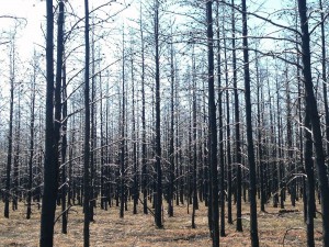
It has been a year and there is a section of the North Country Trail that runs right through the area of the Duck Lake forest faaaarrr. This summer, volunteers working with our own Hiawatha Shore-to-Shore NCT Chapter are working to re-establish the trail: re-routing, blazing, and doing general maintenance work. It can be a trick to blaze a hiking trail after a forest fire. The burned trees haven’t finished falling down yet and probably won’t for a few years. So you can blaze but you will probably have to re-blaze again (and again (and again)). There’s also a *lot* of deadfall to clear and that is also an exercise that’ll have to be repeated again (and again (and again)) as more trees fall down.
We did over nine miles today. Started at the mouth of the Little Two-Hearted River, walked a couple miles beyond the mouth of the Two-Hearted River, then back. Our turn-around point was the beach below the red-pine forested dune where the GG and Mouse camped a couple years ago, *before* the fire.
A beautiful hike and a relatively strenuous one for The Great Lake State, at least with all of the forest fire deadfall. We stopped at the Tahquamenon Falls Brewery for an appetizer and an adult beverage after hiking, then swooshed down M123 and the Whitefish Bay Scenic Byway for home.
The photoooo doesn’t do this particular scene justice. We walked into this section of the burned out forest and at first glance it looked like these trees had been hit by frost or an ice storm. It’s cold this weekend but it’s not *that* cold. 55 degrees or thereabouts at the time I took the photo. This effect is the sun shining out of a cloudless sky, illuminating all of those bare branches.
Tired? Yes yes yes! The GG is on his second nap this afternoon. The first one was in the Frog Hopper on the way home from the brewery. Now he’s in the back bedroom. Me? I don’t usually take naps but I did take a shower, which can function as a nap for me. I wore Smart Wool socks and sandals today and my feet were black! Tomorrow is our last day here for a while. Chores are at hand and we’ll be sticking pretty close to the beach…
May 25th, 2013 at 7:16 pm
9 miles!! That’s impressive! My state has lots of forest fires, but usually in the dry eastern part.